- Arabic
- Policy Analysis
- Fikra Forum
A settlement on the site of the Eviatar outpost could pose a major obstacle to any plans for a Palestinian state.
Media http://www.rajawalisiber.com – The June 30 agreement regarding the future of the Eviatar outpost in Area C of the West Bank represents not only a political success for the new Bennett government, but also a potential Israeli grip on a strategic site that dominates Tapuach Junction and the Trans-Samaria Road, disrupting the continuum of any Palestinian state. In mid-May, the Samaria Regional Council, the Municipal Authority of the Israeli Communities in Samaria, announced that in response to the murder of yeshiva boy Yehuda Guetta by a Palestinian terrorist, they would establish a new outpost on a hill 2 km east of the Tapuach Junction. The Regional Council subsequently erected about sixty light structures on the site. Likewise, about fifty families with children who already live there believe they can build their permanent home on the site, and the head of the regional council moved his temporary office there.
The Samaria Regional Council referred to Eviatar as a settlement rather than an outpost, a characterization also absorbed by Israeli and international media, which are unfamiliar with the sharpness of the legal definitions unique to the West Bank. Establishing a settlement follows a legal procedure, whereas the establishment of an outpost is illegal under Israeli laws.
The Israeli Civil Administration immediately issued a demarcation order afterwards, based on the laws of planning and construction, that prohibited the bringing of buildings and equipment to the site. They also issued a work stoppage order, a preliminary procedure for a demolition and eviction order.
Like many of Netanyahu’s loyalists, the council is happy to present the new government, headed by Naftali Bennett, with the challenge of dealing with and evacuating an “Israeli settlement.” Through this challenge, the council hoped to prove that the Bennett-Lapid government is left-wing and will betray the patriotic values of the Israeli right. The Netanyahu loyalists’ plan was to create a media event and a clash between the security forces and thousands of settlers that would harm the delicate coalition’s public appearance.
Instead, with great political wisdom, the Bennett-Lapid government was able to find a formula that allows the voluntary evacuation of the settlers from the mountain and the continued holding of the place as a military camp. In the subsequent three months, the government will conduct an in-depth examination of the status of land rights and the possibility of establishing a settlement on the site. After the inquiry, the issue will be brought up for discussion in the government.
However, the solution raises the question of the potential impact of this eventual decision, and whether this question should be understood only as a technical procedure of “clear property rights.” The answer requires some clarification of the legal history and administrative realities of Area C.
Pursuant to the Interim Agreement between the State of Israel and the Palestine Liberation Organization signed in September 1995, the Palestinian Authority holds all responsibility and authority in Area A and civil authority in Area B, where the vast majority of Palestinians live, while Area C—which includes the Israeli army zones and camps, border areas, Israeli settlements, and most uninhabited areas—remains under the authority and responsibility of the Israeli military government.
Real Estate Law in Area C is based on Ottoman law predating World War I, along with later laws from the British Mandate and Jordanian Hashemite rule until 1967 and with laws from the subsequent Israeli military administration that has governed the region for the past 54 years.
Under Ottoman law, all lands belonged to the Sultan, who allocated land for the use of the inhabitants of the area in exchange for a usage fee. However, over the years, the Ottoman government reallocated certain lands for the private ownership of officers and government officials registered as private lands in the official Land Registry (Tabo). In contrast, land use rights of most local residents were registered only in the tax books. So, in fact, any land that is not registered as private ownership or private use land is owned by the government (State Lands).
After the fall of the Ottoman Empire, the British Mandate and the Jordanian Kingdom began a process of mapping and registering land use rights. However, when the process came to a halt with the 1967 war, only about 40 percent of the lands in the area had been registered in the Land Registry.
In the early 1980s, the Israeli Military Administration began locating and registering public lands as state lands in the land registers books. The Deputy Attorney General at the time, Adv. Pleia Albeck, headed a legal team that explored the area with new and old aerial maps and photographs and toured the various territories. The legal team likewise conducted a public “declaration of state lands” procedure, in which they heard Palestinians’ ownership claims. To date, this process remains incomplete, both due to the complexity of the process and the geopolitical changes that have taken place in the region.
Today, a Palestinian who wishes to register his ownership of land in Area C on the basis of the rights recorded in the tax books must prove that the land has been in use since 1967 or that Israeli rule has prevented the use of the land. If the land or part of the land has not been used, or alternatively is not considered suitable for agricultural use, the Commissioner of Government Property claims ownership of the land, and a legal process allows for the land to be registered as government-owned.
Through this process, there are extensive lands in Area C deemed by the Ministry of Justice’s survey team as meeting this criterion to be claimed as State Lands. However, the public process has not been completed, and these lands hold the legal status of “lands claimed by the Commissioner”, or, in the vernacular, “survey lands.”
Eviatar’s settlers claim that the plot of land around the outpost falls under this latter category, claiming it is owned by the Military Administration even if the land has not yet been officially registered as State Land. To support their claim, the settlers prepared a legal file with professional opinions and ostensible evidence that the land is pit land and has not been cultivated since 1967. Therefore, the state could approve the establishment of a new settlement there. Settlers also referenced old documents proving that the Civil Administration had begun a “declaration” process in this area, but that the process has not been completed.
The Samaria Regional Council seeks for the military commander to issue a court order for the new settlement jurisdiction, and the council has already prepared and submitted a detailed master plan for a permanent settlement to the competent planning committees. Of course, the committees cannot start discussing these plans until the military commander issues a jurisdiction order to the settlement.
Beyond the procedural, legal, and political issues, however, two other key questions arise regarding the government’s decision on the Eviatar site: should the government allow and promote the establishment of an invasive and illegal outpost, given the current public demand for the evacuation of similar Bedouin illegal outposts in large areas of state land in Beersheba area? More to the point, there also remains a hidden question, one that did not feature in the public debate in Israel over the issue. This is the question of whether allowing the establishment of an Israeli settlement on the site near Tapuach Junction would make it difficult to establish a future Palestinian state.

The strategic importance of Tapuach Junction is best understood in terms of the larger power struggle between the Palestinian Authority and Israeli settlers over control of Area C. The Palestinian Authority, with the support and funding of NGOs and even a number of European governments, is implementing a plan to establish a grip on Area C without building permits from Civil Administration authorities or even manage and register ownership rights, ostensibly, in state lands. The Civil Administration has difficulty enforcing planning and building laws, mainly for political reasons, and has refrained from demolishing Palestinian buildings. On the other hand, the settlers are also trying to establish their hold on the lands and establish agricultural farms and residential neighborhoods on state lands without obtaining the legal permits. Whether for political reasons or for security reasons, the Civil Administration enforces the law against Israelis more easily. The Israeli army is also expected to manage the friction that often occurs between Palestinian and Israeli shepherds, farmers, and residents while preventing damage to lives and property.
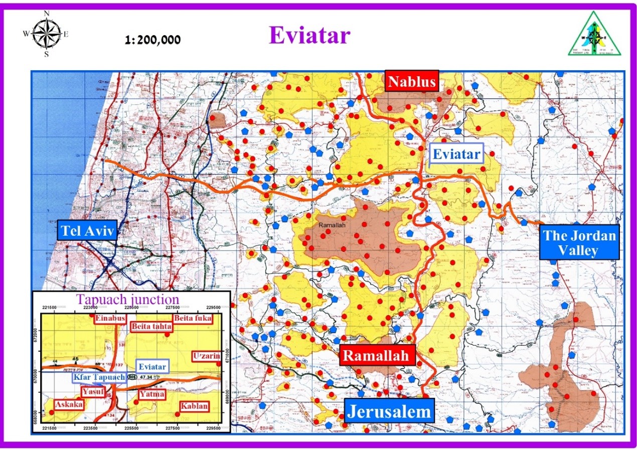
The young Eviatar outpost was located at the top of a hill dominating Tapuach Junction. This major junction connects Palestinian and Israeli traffic: the mountain road (Route 60)—connecting Jenin and Nablus in the north and Ramallah, Bethlehem and Hebron in the south—intersects Road 505 or “Trans-Samaria Road”—the main axis for Israelis from Gush Dan and Ariel to the Jordan Valley. As such, Tapuach Junction is busy with Palestinian and Israeli traffic around the clock.
In the official Israeli concept of security, Israeli control of this strategic junction is of great importance, both for the security of routine life and for preventing the invasion of foreign army forces from the east through the Jordan Valley into the heart of the State of Israel during a war.
Yet in all the various proposals raised in the permanent status negotiations, including the Camp David Conference in 2000, the Taba Conference in 2001, the Annapolis Conference in 2008 and Prime Minister Olmert’s proposal in 2009, Tapuach Junction was invariably proposed to be transferred to Palestinian control.
Likewise in President Trump’s January 2020 “Deal of the Century,” the junction and its surrounding area were also to be part of a future Palestinian state. The proposal for Israeli access to the Jordan Valley was via a bypass road through an Israeli settlement area.
There is a strategic reason that the leaders of the settlers in Samaria chose this hill to establish the new settlement of Eviatar. Government recognition of a new settlement in this region would anchor the Israeli demand for control of the strategic road and would reduce the possibility of promoting an alternative solution that will allow Israeli access to the Jordan Valley without interrupting the main Palestinian traffic route. The presence of an Israeli civilian settlement there would likewise require the evacuation or relocation of civilians in any plan of geographical separation between Israel and the Palestinians, so as not to harm the need of a future Palestinian state to maintain a continuum of land control in the northern West Bank. In short, establishing a settlement at Eviatar would prevent a Palestinian continuum that would enable the existence of a future Palestinian state within any two-state solution.